
Click on image to go to NASA page containing original image
U.S. Air Force Defense Meteorological Satellite Program (DMSP) satellites are in low altitude (840 km) sun-synchronous polar orbits with an orbital period of 101 minutes. With 14.4 orbits per day they generate a global night time and day time coverage of the Earth every 24 hours with their main purpose to monitor the distribution of clouds and to assess navigation conditions.
The Operational Linescan System (OLS) is an oscillating scan radiometer with low-light visible and thermal infrared (TIR) imaging capabilities which first flew on DMSP satellites in 1976. At night the OLS uses a Photo Multiplier Tube (PMT) to intensify the visible band signal. The purpose of this intensification is to observe clouds illuminated by moonlight. The PMT data have a broad spectral response from 440 to 940 nm (485 - 765 nm FWHM) with highest sensitivity in the 500 to 650 nm region. This covers the range for primary emissions from the most widely used lamps for external lighting: Mercury Vapour (545 nm and 575 nm), High Pressure Sodium (from 540 nm to 630 nm), Low Pressure Sodium (589 nm). The image below is a composite night-time OLS images in the visible light band showing the Earth at night. It was put together byC. Mayhew & R. Simmon (NASA/GSFC), NOAA/ NGDC, DMSP Digital Archive .
The OLS acquires swaths of data that are 3000 km wide. The OLS sinusoidal scan maintains a nearly constant along-track pixel-to-pixel ground sample distance (GSD) of 0.56 km. Likewise, the electronic sampling of the signal from the individual scan lines maintains a GSD of 0.56 km. The effective instantaneous field of view (EIFOV) is larger than the 0.56 km GSD and varies with scan angle. At nadir the EIFOV is 2.2 km and expands to 5.4 km at the edge of scan 1500 km out from nadir. Most of the data received by NGDC has been "smoothed" by on-board averaging of 5 x 5 pixel blocks, yielding data with a GSD of 2.8 km.
DMSP platforms are stabilized using four gyroscopes (three axis stabilization),
Please read this Data Usage Notice
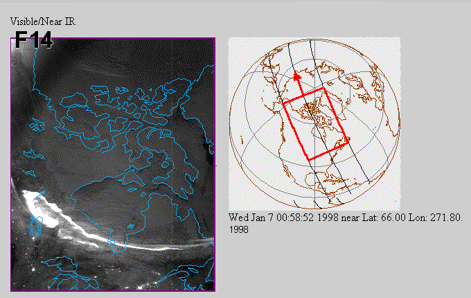
and platform orientation is adjusted using a star mapper, an Earth limb sensor, and a solar detector. Daily radar bevel vector sightings of the satellites provided by Naval Space Command allow Air Force orbital mechanics models to compute geodetic subtrack of each orbit giving the position of satellites every 0.4208 seconds. This position together with OLS scan angle equations, an oblate ellipsoid Earth sea level model and digital terrain elevations from U.S. Geological Survey, EROS Data center, allow geolocation algorithms to estimate latitude and longitude for each pixel center.Below is a sample of a DMSP visible light image over 1/8th of an orbit over the high latitude, night time sector. The bright band across the bottom of the image is caused by the aurora.
Please read this Data Usage Notice