The Ion Drift Meter (IDM) sensor on SSIES & SSIES2 measures the bulk velocity of thermal ions traveling perpendicular to the DMSP spacecraft's path. The horizontal component of the cross-track flow is equivalent to the component of the electric field parallel to the spacecraft's path. By summing up (or integrating) this electric field as the spacecraft flies across one of the Earth's polar regions, the electrostatic potential (voltage) across the polar region can be determined.
The algorithm for the "cross-cap potential" was developed by Marc Hairston and Rod Heelis of the University of Texas at Dallas. The primary users of the potential data are the USAF Research Lab., USAF 55th Space Weather Squadron, and Rice University. The data are also available to anyone in the geophysical community.
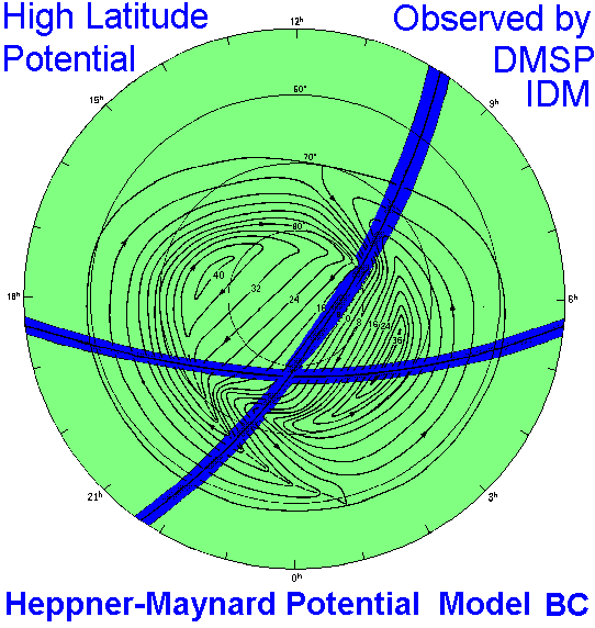
When a low density plasma, such as the plasma of the ionosphere above approximately 200 km altitude, moves in the presence of a magnetic field, there must be an electric field associated with that motion. The solar wind forces the plasma which is attached to the Earth's magnetic at high altitudes (>> 6000 km) to move. This motion is transmitted down the magnetic field lines to the ionosphere and the plasma in the ionosphere mirrors the motion of the plasma at high altitudes. The plasma in the auroral zones (approximately between magnetic latitudes of 65° and 75°) moves sunward and the plasma at higher latitudes (the polar cap) moves anti-sunward. The figure below shows a representation of this pattern of ionospheric plasma flowing about the North Pole.
Each streamline in the figure represents a level of constant electrostatic voltage. The pathways across the region represent two typical tracks of DMSP spacecraft. By measuring the motion of the ions across the path of the spacecraft with the IDM, the DMSP spacecraft obtains a sample of the pattern. With the aid of other data and/or matching the data to statistical patterns, the whole pattern can sometimes be deduced from the sample of the "cross-cap potential" obtained by the IDM.
The DMSP IDM data is processed by a program (see references below) that creates 4 sec averages of the ion drifts. These ion drift data are then converted to the component of the electric field along the spacecraft trajectory. The potential at each point across the high latitudes is the integral (or summation) of the electric field from approximately 50° magnetic latitude to that point. It is assumed that the electric field at mid-latitudes is zero. If the activity level is very high and the high latitude region is greatly expanded, the 50° mag. lat. starting point will be moved to a lower latitude. Below is a graph of the IDM and potential data for one pass through high latitudes.
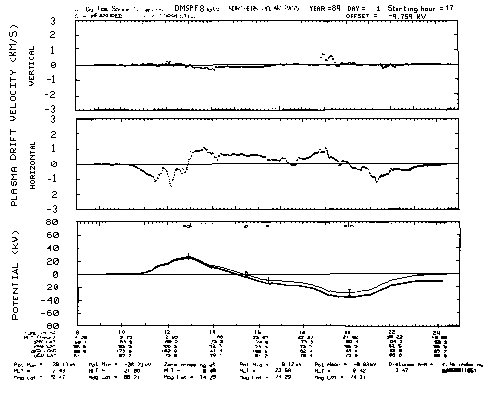
The top box is the plot of the vertical component of the ion drift versus time; the vertical data provide a very minor component of the potential calculation since the magnetic field at high latitude is almost parallel to the vertical direction. The middle box is the plot of the horizontal component of the ion drift versus time. The bottom plot is the result of using the horizontal ion drift to find the potential at each point along the spacecraft's path. Notice that there are two curves. The curve that starts at zero on the left and ends near zero, but NOT at zero, on the right is the first or "uncorrected" potential. By forcing the potential back to zero on the right, the algorithm obtains the "corrected" potential. A correction of approximately 5 kV is due to instrument effects. The correction is often much greater becuase of changes in the geophysical environment during the 15 to 20 minutes required for the spacecraft to traverse the high latitude region.
The distribution of the "corrected" potential along the spacecraft's path is matched to the 3 southward IMF patterns developed by J. Heppner and N. Maynard. One of the patterns is shown above. The algorithm determines which of the 3 patterns of potential best fits the data and estimates the true maximum and minimum potential across the whole high-latitude region based on the observed maximum and minimum and the choice of Heppner-Maynard pattern. If the potential difference between the observed maximum potential and observed minimum potential is less than 40 kV and greater than 10 kV and the observed pattern does fit any of the 3 patterns, the algorithm estimates that the IMF was northward during the pass. If the highest magnetic latitude along the spacecraft's path is less than 75°, the algorithm makes no estimate of the global potential pattern. If the observed difference between the maximum and minimum potential is less than 10 kV, the algorithm assumes that the spacecraft track missed too much of the convection pattern to get anything useful out of the data for the pass.
The result of the integration of the potential along the spacecraft's path is written out to a "long" file. The result of the matching of the potential along the path to models of the global distribution of potential is written out to a "short" file. The "long" file is a VAX/VMS compatible binary file or the machine-independent HDF format. Upon request, the "long file" can be converted to ASCII format. The short files is a text file. For a description of the contents of the "long" file (the 4 sec averages of the Ion Drift Meter (IDM) on SSIES/SSIES2) and the "short" file (one line summary of each half orbit), see Marc Hairston's DMSP Data Description Web Page.
The Cross Cap Potential was developed for use by the Air Force Space Forecast Center as a method of processing the SSIES data for use with the Magnetospheric Specification Model ( MSM ) developed by Rice University. (MSM is a specialized version of the Rice Convection Model which has been used for research and been under continuous improvement by Rice University for the past 15 years.) During active period, AFSFC obtained obtains the DMSP data minutes after the high-latitude pass of the spacecraft and immediately calculates the Cross Cap Potential for their use and the use of space forecast personnel at SEL/NOAA.
The Cross Cap Potential data is available to anyone in the geophysical research community who requests it. In particular, it has been used as input to the Assimilative Mapping Ionospheric Electrojet ( AMIE ) model at NCAR, by various members of the Geospace Environmental Modelling (GEM) community, the ionospheric modelling ( CEDAR or Coupling, Energetics and Dynamics of Atmospheric Regions) community and the National Space Weather Initiative community. Anyone who uses the potential data is asked to share their results with the developers of the potential algorithm so that we can make improvements in the algorithm.
No data set is without limitations. The first question that often comes up is, "What is accuracy of the potential data?" Since there are several factors which affect the accuracy of the potential data and some of these are unknowable, there is not a firm number, such as a standard deviation, which clearly tells the user the accuracy level. The "offset" potential, or the amount of correction applied at the right side of the above figure, is the best measure of accuracy available. There is also a "quality flag" given in the "short" file which indicate potential problems with a given pass across the high latitude region.
Here is a brief summary of some of the factors which can limit the usability of the potential data:
The "Cross Cap Potential" data is available by sending email to Marc Hairston at Univ. of Texas at Dallas. Please specify whether you want "long" files or "short" files or both. Data are stored off-line in one day files and it generally easiest to make a full day of data available.
Go to DMSP Home Page