The DMSP magnetometer data is available as one second averages of the measured magnetic field minus the IGRF model magnetic field.
Below are some plots of the y and z components (delta-Bz and delta-By) of the difference vectors as a function of time for one orbit (one northern hemisphere pass and one southern hemisphere pass) of the DMSP/F13 spacecraft on 18 Oct 95. The same data are plotted in 2 different manners.
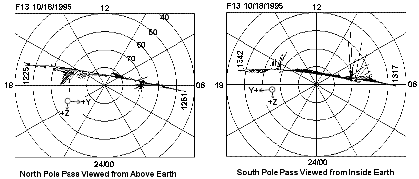
First the data are plotted as disturbance vectors on a polar grid of corrected geomagnetic latitude and magnetic local time. The base of each vector is located at the position of the DMSP/F13 spacecraft in coordinates of magnetic latitude - magnetic local time. Magnetic local noon is at the top of the plot and magnetic local time of 06 hours is at the right side of each plot. The direction and length of each vector represents the direction and magnitude of the disturbance vector. The direction of the vector is obtained by rotating the two horizontal components of the magnetic disturbance vector (delta-Bz, delta-By) from spacecraft coordinates to geomagnetic coordinates. The plot for the northern hemisphere is the view seen looking down on the North Pole. The plot for the southern hemisphere is the view seen looking down from the North Pole, through a transparent Earth to the South Pole.
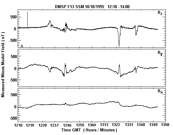
The figure below shows the same magnetic disturbance vector data plotted as line plots as a function of time in the coordinate system of the instrument with respect to the spacecraft. The Z components (delta-Bz) is the top trace, the Y component (delta-By) is the middle trace and the X component (delta-Bx) is the bottom trace. . By comparing the time at the bottom of the line plots with the time tag on the polar plots, you can determine the orientation of the spacecraft's y and z axes.
The SSM was built with the intention of aligning the sensor's internal coordinate system with the spacecraft's coordinate system within the accuracy of the mounting. Due to interference found during initial testing of SSM on the DMSP spacecraft, it was necessary to move the sensor from the bottom panel to the structure between the equipment module and the apogee kick motor (AKM). This required a rotation of the sensor in order to mount it. The SSM sensor's coordinate are: The +X component of the measured magnetic field is down along the local vertical direction. The +Y component of the measure field is perpendicular to +X and in the forward direction. Since the spacecraft's velocity vector is not exactly perpendicular to the local vertical direction at all time, there is a very small angle between the SSM +Y direction and the spacecraft's velocity vector. The +Z component of the measured field is perpendicular to +X and +Y in the sense of a right-handed coordinate system. Thus +Z is toward the night side of the orbit plane. This is shown on the polar-vector plot above. SSM sensors on F15 and beyond are mounted on a platform at the end of a boom, but the sensor orientation has not changed.
The F12, F13 and F14 instruments are close to other instruments and power systems that create magnetic field that can be seen in the SSM data. Most of the major spacecraft magnetic fields have been removed during data processing, but not all. Any time some sees an instantaneous change of 10 - 100 nT in the data and the reverse of this change 20 to 300 seconds later ( like a square wave added to the data ), one is looking at spacecraft magnetic field that has not been removed by the processing. Also, if one looks very closely at the line plot of the three components versus time, one will see that the lines are going up and down by ~10 to 20 nT due to spacecraft generated noise that has not been removed by the data processing. For F15 and beyond, this noise is not present in the data because the sensor is on a boom and the noise magnitude decrease as distance cubed.
The lines representing the components of the magnetic deflections should be flat lines when the spacecraft is always from the high latitude regions. It is obvious that the line are not flat. Part of this is due to errors in the model magnetic field. However part of the slow variation in the components is due to small errors in the ephemeris data and to calibration problems. Most of the data processing is done with the ephemeris included with the raw data. This ephemeris may be in error by several nautical miles in the downrange direction which is equivalent to 1 or 2 seconds of error in the time of the ephemeris. For special cases, the ephemeris can be reconstructed so that the errors are greatly reduced and these slow variation in the components are minimized.
The magnetic deflection data are available upon request from K. Martin ( kevin.martin@bc.edu ). The files have been written as binary files on a Sun workstation. All of the numbers in the files are integers. Each file of data represents one day of data. Each record in the file represents one minute of data. Missing or unusable seconds of data are presented by dummy values within a record. If a whole minute of data is missing or unusable, the data record has been deleted from the file. An IDL program is available for reading the files and making the above plots.
After making your request, the files will be retrieved manually. Please be patient if you do not obtain an immediate reply.
All magnetic disturbance vector data from the F12 - F18 spacecraft are available for research related to topics of interest to the Air Force. There are some small gaps due to missed downloads from the spacecraft, poor quality communications links, corrupted telemetry files, and various other factors.
updated: Oct 2012
Please read this Data Usage Notice
Go to DMSP Home Page