Go to DMSP Home Page
We are all familiar with changes in the lower layers of the Earth's atmosphere. One day the sky is clear; the next day it is cloudy. One day the temperature is warm; the next day it is cold. We call these changes in our environment "weather". We need to know about these changes because the affect how we live.
The environment in the top layer of the Earth's atmosphere (the thermosphere / ionosphere) and beyond also changes from hour to hour and from day to day. While rain and clouds do not exist in these regions, it is reasonable to refer to the changing space environment as "space weather." Because there are astronauts living in space and an array of spacecraft needed for daily business activities, we need to know about space weather. And just like ground-level weather, storms in space may disrupt routine activities.
Here are some useful sites on the web for finding out more about space weather:
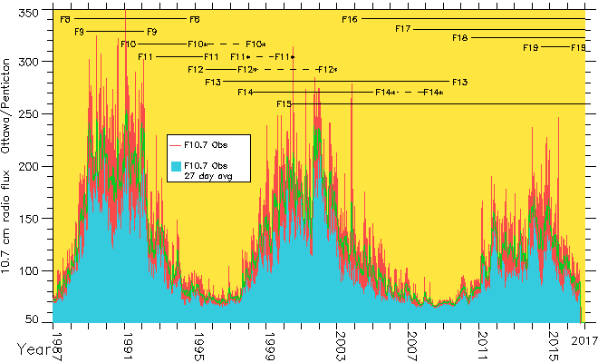
Below is a graph of the flux of radio noise at the 10.7 cm line in the Sun's electromagnetic spectrum. This line is used as a proxy for the Sun's output of extreme ultra-violet (EUV) radiation. The flux of radiation in the EUV part of the spectrum is the major factor in the creation of the Earth's ionosphere. Like Sun Spots, the EUV flux varies on an 11 year cycle. It also varies from day to day. Across the top of the plot are bars showing the lifetime of DMSP spacecraft monitoring the topside ionosphere. (courtesy of Fred Rich MIT/LL)
The spacecraft of the Defense Meteorological Satellite Program (DMSP) are a series of polar-orbiting spacecraft with orbital height above the mean radius of the Earth of 835 km. to 850 km. (519 to 528 statute miles or 450 to 458 nautical miles). There are nominally two satellites in operation at all times, but the past decade there have been up to 4 spacecraft active at any given time. As a spacecraft nears its end-of-life, it is replaced with a new spacecraft. DMSP spacecraft started flying in the 1960's and are scheduled to keep flying until approximately 2020. As new spacecraft have been built, the technology of both the spacecraft and the instruments have evolved. The spacecraft are placed into orbits that are fixed in local time with equatorial crossing times near either 06:00 local time and 18:00 local time or near 09:00 local time and 21:00 local time.
The primary mission of DMSP spacecraft is to remotely observe the tropospheric and stratospheric weather (ground level to 20. miles (32 km) altitude). The principal sensor system used to accomplish this mission is the Operational Linescan System (OLS), a high resolution (2.8 km), white-light and infrared imaging system. A companion spacecraft to DMSP are the TIROS or NOAA/POES series of spacecraft built by a NASA contractor and flown by the National Oceanic and Atmospheric Administration. As part of the combining of these two programs, all DMSP spacecraft in space have been managed by NOAA since 1997.
The secondary mission of DMSP is to monitor the near-Earth space environment, which is important to the Air Force because of the various ground-based and space-based systems that can be affected by changing conditions in space. AFRL has been providing space weather instruments for DMSP on flights since 1977. These instruments included the auroral particle spectrometer (SSJ3, SSJ4 and SSJ5), the top-side ionospheric plasma monitor (SSIE, SSIES, SSIES2 and SSIES3), and the fluxgate magnetometer (SSM). Starting in 2001, a down-ward looking ultraviolet imaging system (SSUSI) provided by the Applied Physics Lab of Johns Hopkins University and a horizon-looking ultraviolet imaging system (SSULI) provided by the Naval Research Lab. will be added to the space weather instrument set on DMSP spacecraft on orbit. The name "SS-something" are not abbreviations; they are brief acronyms used by the program managers. The "SS" part of the acronym indicates that the instruments are part of the secondary sensor system on the spacecraft.
More information about DMSP can be found at:
Go to DMSP Home Page